Joint research by KIOST, Seoul National University and US NOAA
Flood cycles accelerating, with recent events clustering in even-numbered years
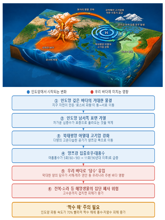
Large-scale flooding along China's Yangtze River has become more frequent in recent years, and researchers say the cause lies thousands of kilometers away — in shifting wave patterns deep beneath the Indian Ocean. The research team also said the low-salinity water produced by Yangtze floods can spread as far as Jeju and the West Sea coast, and that the findings could help predict damage to South Korea's marine ecosystems.
The Korea Institute of Ocean Science and Technology (KIOST) said Monday that a research team led by Vice President Kang Dong-jin, working jointly with Seoul National University, the US National Oceanic and Atmospheric Administration and India's Indian Institute of Tropical Meteorology, had identified how changes in the Indian Ocean drive summer flooding across East Asia.
Analyzing 65 years of Yangtze River flow data along with ocean and atmospheric observations collected since 1960, the team confirmed that Rossby waves — large-scale ocean waves generated by Earth's rotation — play a key role in triggering East Asian floods.
As Rossby waves travel across the Indian Ocean, they suppress the upwelling of cold deep water to the surface, raising sea surface temperatures in the southwestern Indian Ocean.
The thermal energy generated in this process strengthens the North Pacific subtropical high-pressure system, which in turn channels large volumes of water vapor into the Yangtze River basin, triggering heavy rainfall and flooding.
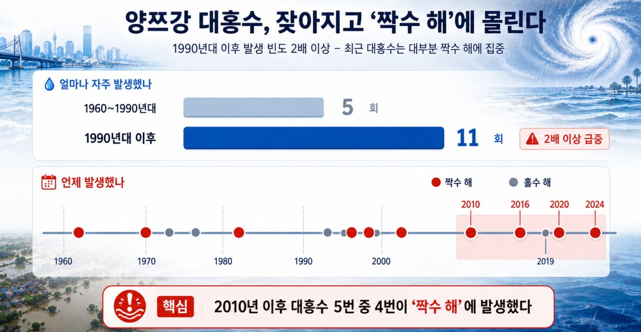
The researchers also found that flood cycles have accelerated of late. The speed of Indian Ocean waves has increased by roughly 70 percent compared with the past, strengthening the alignment between ocean warming and East Asia's rainy season.
Major floods in the Yangtze basin occurred five times between 1960 and the 1980s, then jumped to 11 times from the 1990s onward. Since 2010, all major floods except one in 2019 have struck in even-numbered years — 2010, 2016, 2020 and 2024.
The team said the findings could be used to improve the accuracy of East Asian flood forecasting.
Nam Sung-hyun, a professor at Seoul National University, said incorporating ocean wave data into climate prediction models would allow more precise forecasting of extreme weather events such as floods. "The roughly two-year cycle has become increasingly pronounced of late, so we need to be prepared for Yangtze River flooding in even-numbered summers," he said.
The research also carries implications for South Korea's marine environment and fisheries industry. When large volumes of freshwater flow in from Yangtze floods, low-salinity water forms and can spread to the coasts of Jeju and the West Sea.
Low-salinity water disrupts the osmoregulation of bottom-dwelling organisms such as abalone and top shells that cannot easily move, and can trigger mass die-offs. The damage can be even greater when low salinity and high water temperatures occur at the same time.
KIOST said sea surface temperatures around the Korean Peninsula are forecast to run above normal this summer, making it particularly important to monitor whether Yangtze River flooding materializes.
Kang said the research had traced the process by which small changes in the Indian Ocean lead to extreme weather events across East Asia. "We are now in an era where Korean Peninsula weather can only be fully explained by looking not just at surrounding seas but all the way to the Indian Ocean," he said.
adastra@heraldcorp.com