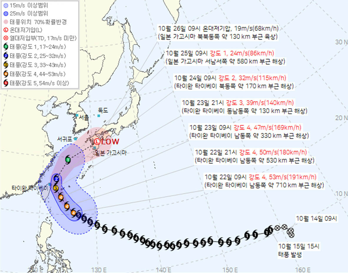
Super Typhoon Champi is unlikely to make landfall on the Korean Peninsula, but residents in southern regions and Jeju should brace for strong winds, high waves and heavy rain, authorities warned.
According to the Korea Meteorological Administration, Champi — the 30th named typhoon of the year — was moving northwest Thursday morning at Category 4 intensity, located about 710 kilometers southeast of Taipei, Taiwan. The storm is expected to change course around Saturday, turning toward Japan's Kyushu region.
The typhoon is forecast to pass closest to South Korea around Sunday, when it is expected to be roughly 580 kilometers west-southwest of Kagoshima, Japan. At that point, parts of the South Sea could fall within the typhoon's strong-wind radius.
If a typhoon advisory is issued, Champi would be classified as a typhoon that affected South Korea — which would make it the latest on record to do so since 1951. The previous record was held by Typhoon Zeb, which did not make landfall but affected the country from Oct. 16 to 18, 1998.
Champi is expected to draw moisture northward from the south in tandem with a subtropical high-pressure system to Japan's southeast, funneling rain into South Korea.
Rain is forecast to begin in Jeju on Friday afternoon, spreading overnight to parts of the southern coasts of South Jeolla Province and South Gyeongsang Province. The wet weather is expected to continue through Sunday across southern regions and Jeju, with some areas of South Chungcheong Province also seeing rain Sunday afternoon.
Forecast rainfall totals for Friday through Saturday include 30 to 80 millimeters for most of Jeju, 10 to 40 millimeters for northern and western Jeju, 5 to 30 millimeters for Gwangju, South Jeolla Province, Busan, Ulsan and South Gyeongsang Province, 5 to 20 millimeters for Daegu and North Gyeongsang Province, and 5 to 10 millimeters for North Jeolla Province.
Beyond rain, residents should also prepare for strong winds and high seas. Gusts exceeding 55 kilometers per hour — and up to 70 kph in mountainous areas — are expected in Jeju from Friday afternoon and along the southern coast from Saturday. The strong winds could disrupt flights, and travelers using Jeju air routes are advised to check flight status in advance.
Swells are already moving into Jeju's coastal waters from Thursday and will reach the southern coast from Friday, bringing powerful waves. Winds of 30 to 65 kph (8 to 18 meters per second) and waves of 1.5 to 4 meters — with peaks exceeding 5 meters — are expected for now in the waters south of Jeju and the outer eastern South Sea.
A direct landfall on the Korean Peninsula remains unlikely for now. Sea surface temperatures around the peninsula are not high enough to sustain the typhoon's intensity, and the storm is expected to track along the edge of the subtropical high-pressure system to Japan's southeast, steering it toward Kyushu.
A powerful jet stream is forecast over the upper atmosphere above South Korea around Sunday, moving rapidly from west to east — a pattern that would block the typhoon from pushing further north.
Uncertainty remains, however. If the subtropical high-pressure system to Japan's southeast expands further west than currently projected, Champi could weaken as it passes through Taiwan and southeastern China before moving toward South Korea, rather than curving directly toward Japan from waters east of Taiwan. The European Centre for Medium-Range Weather Forecasts model currently assigns a relatively high probability to this scenario.
Even a weakened low-pressure system born from a typhoon can bring heavy rainfall and cause significant damage. A low-pressure system that had weakened from Typhoon No. 13, Dolphin, was responsible for record-breaking downpours in Geoje and surrounding areas during the Liberation Day holiday earlier this year.
betterj@heraldcorp.com